

Close Menu
ParametricParametric

    Subscribe to Updates

    Get the latest creative news from FooBar about art, design and business.

    What's Hot

    tetsstststtt

    July 23, 2026

    Soundscape in Architecture: Designing Through Sound

    July 23, 2026

    MVRDV Wins Shift Embassy Competition with Rotterdam ROCKS!

    July 23, 2026
    Facebook X (Twitter) Instagram
    Facebook X (Twitter) Instagram Pinterest YouTube LinkedIn TikTok
    ParametricParametric
    Courses
    • Articles
      • Archipreneurs
      • Technology
      • BIM / AEC
      • 3D Printing
      • Architects
      • Artificial Intelligence
      • Robotics
      • Sustainability
      • Tools
      • Case Study
      • City Guide
      • Opinions
      • Interviews
      • Architecture & Design
        • Urbanism
        • Metaverse
        • Space Architecture
        • Geography
    • Projects
      • Architecture
      • Interior
      • Design
        • Fashion
        • Pavilion
        • Installation
        • Digital Art
        • Landscape Design
      • Products
    • Workshops
    • Ads
    • Architecture News
    • Digital Members
    • Books
    • CDNext
    • CDNEXT Recordings
    • Competitions
    • Events
    • PA Talks
    • Jobs
    • landscape
    • Landscape Architecture
    • PA Quotes
    • PAACADEMY
    • podcasts
    • memorial
    • Studio Recordings
    • Studio Workshops
    • Uncategorized
    • Videos
    ParametricParametric
    Home»Architecture News»How AI and satellite imagery is helping disaster response efforts?
    Architecture News

    How AI and satellite imagery is helping disaster response efforts?

    adminparametBy adminparametJuly 23, 202603 Mins Read0 Views
    Facebook Twitter Pinterest LinkedIn Tumblr WhatsApp Reddit Email
    Share
    Facebook Twitter LinkedIn Pinterest Email
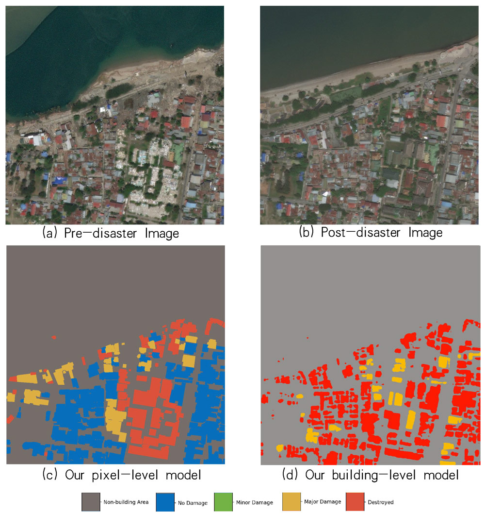
    Technical Solution Discussion for Key Challenges of Operational Convolutional Neural Network-Based Building-Damage Assessment from Satellite Imagery: Perspective from Benchmark xBD Dataset

    Machine learning is being used by humanitarian organizations in Turkiye and Syria to quickly assess earthquake damage and plan rescue attempts. So, how AI and satellite imagery is revolutionizing disaster response efforts?

    XView2 is an open-source project that combines machine-learning algorithms and satellite photos to identify and analyze building and infrastructure damage in disaster situations. It was created in 2019 by the Pentagon’s Defense Innovation Unit and Carnegie Mellon University’s Software Engineering Institute, with collaboration from Microsoft and the University of California, Berkeley.

    The program has been used in disaster response efforts by international organizations such as the US National Guard, the United Nations, and the World Bank. In California and Australia, it was deployed in response to wildfires, and in Nepal, it was used during recovery efforts after flooding to identify damage caused by landslides. In Turkey, it has been used by search and rescue personnel from the UN’s International Search and Rescue Advisory Group to find areas that were damaged but previously unknown. The program has also been used by Turkey’s Disaster and Emergency Management Presidency, the World Bank, the International Federation of the Red Cross, and the United Nations World Food Programme.
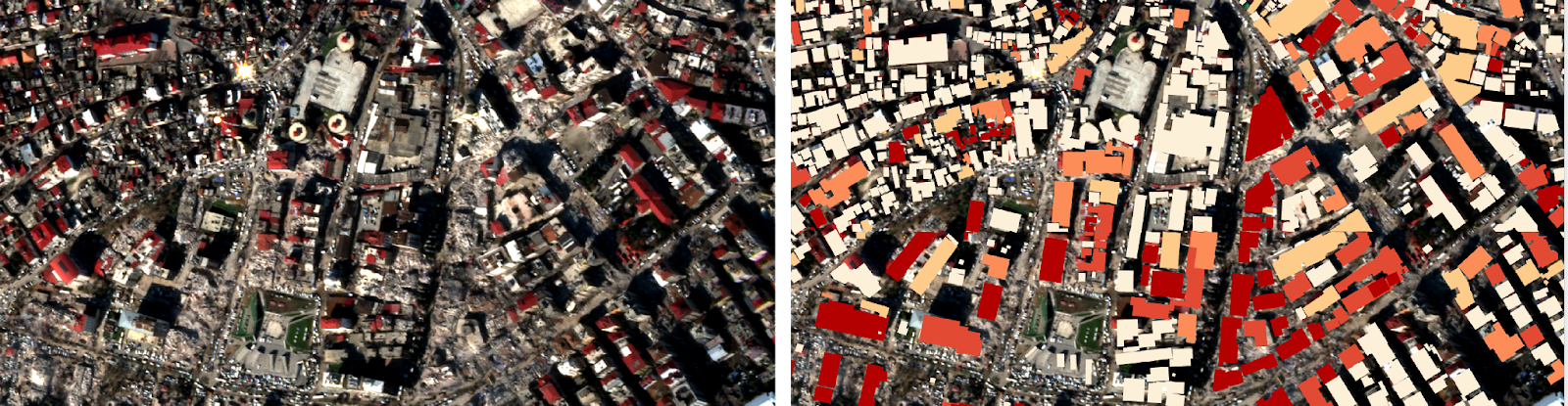
    Kahramanmaras, Turkey: Planet Labs PBC satellite imagery (left) and xView2 output (right) credited to UC Berkeley, the Military Innovation Unit, and Microsoft. via MIT Technology Review

    The program uses a technique called “semantic segmentation,” which evaluates each individual pixel of an image and its relationship to adjacent pixels to draw conclusions. This allows the program to provide a quick assessment of the severity of the damage in the disaster area. Traditional disaster assessment systems rely on eyewitness reports and calls, which can take weeks to provide the same degree of assessment that xView2 can provide in hours or even minutes. Fixed-wing aircraft like drones have been used to provide data, but this can still take days to review. XView2 provides a shared map of the affected area in minutes, which helps organizations coordinate and prioritize responses.

    XView2 has been used to save lives and aid in finding survivors in disaster areas. Ritwik Gupta, the principal AI scientist at the Defense Innovation Unit and a researcher at Berkeley, says that if the program can save one life, it is a good use of the technology. The program’s ability to quickly assess the damage and categorize its severity can help first responders and recovery experts on the ground coordinate reconstruction efforts over time.

    According to MIT Technology Review‘s news, Gupta says getting on-the-ground organizations to use and trust an AI solution has been difficult. “First responders are very traditional,” he says. “When you start telling them about this fancy AI model, which isn’t even on the ground and it’s looking at pixels from like 120 miles in space, they’re not gonna trust it whatsoever.” 

    artificial intelligence disaster relief disaster response efforts GEN Machine Learning
    Share. Facebook Twitter Pinterest LinkedIn Tumblr Email
    adminparamet
    • Website

    Related Posts

    External Reference’s Deportienda Features a Massive 3D-Printed Wave Inspired by the Atlantic

    July 23, 2026

    MVRDV Wins Shift Embassy Competition with Rotterdam ROCKS!

    July 23, 2026

    Soundscape in Architecture: Designing Through Sound

    July 23, 2026
    Add A Comment
    Leave A Reply Cancel Reply

    Demo
    Top Posts

    Design Reviews Are Moving Beyond Still Images and Animations. D5 3.1 Shows What’s Next.

    July 23, 20268 Views

    tetsstststtt

    July 23, 20264 Views

    World Architecture Festival Unveils 2026 Shortlist Featuring 416 Projects Worldwide

    July 23, 20264 Views

    15 Picturesque Neighborhoods Around the World Every Design Lover Should Visit

    July 23, 20263 Views
    Don't Miss

    tetsstststtt

    By adminparametJuly 23, 2026

    Soundscape in Architecture: Designing Through Sound

    July 23, 2026

    MVRDV Wins Shift Embassy Competition with Rotterdam ROCKS!

    July 23, 2026

    Shanghai’s Pollinator Machine Installation Brings Ancient Evolution to Life

    July 23, 2026
    Stay In Touch
    • Facebook
    • Twitter
    • Pinterest
    • Instagram
    • YouTube
    • Vimeo

    Subscribe to Updates

    Get the latest creative news from SmartMag about art & design.

    Demo
    About Us
    About Us

    Your source for the lifestyle news. This demo is crafted specifically to exhibit the use of the theme as a lifestyle site. Visit our main page for more demos.

    We're accepting new partnerships right now.

    Email Us: [email protected]
    Contact: +1-320-0123-451

    Our Picks

    tetsstststtt

    July 23, 2026

    Soundscape in Architecture: Designing Through Sound

    July 23, 2026

    MVRDV Wins Shift Embassy Competition with Rotterdam ROCKS!

    July 23, 2026
    Most Popular

    Design Reviews Are Moving Beyond Still Images and Animations. D5 3.1 Shows What’s Next.

    July 23, 20268 Views

    tetsstststtt

    July 23, 20264 Views

    World Architecture Festival Unveils 2026 Shortlist Featuring 416 Projects Worldwide

    July 23, 20264 Views
    Facebook X (Twitter) Instagram Pinterest YouTube LinkedIn TikTok
    • Home
    • Buy Now
    © 2026 ParametricArchitecture. All Rights Reserved. By utilizing this website, you are consenting to our User Agreement, Privacy Policy, and Cookie Statement. In compliance with the privacy laws of Turkey and the United States, we recognize and respect your rights. Please be aware that we may receive commissions for products bought through our affiliate links. Unauthorized reproduction, distribution, or transmission of any material from this site is strictly forbidden without prior written permission from ParametricArchitecture.

    Type above and press Enter to search. Press Esc to cancel.

    Sign In or Register

    Welcome Back!

    Login to your account below.

    Lost password?